*Note: To try and condense what will already be a longer than usual post. All food and restaurant info is posted at the end. As well as links to the sites for places we visited and used (when available)

Road Trip!
A thrown together “brocation” with one of my
brothers, in the Miata to Floridas nature coast.
A much-needed vacation approaching, I quickly decided I needed to get away from EVERYTHING for at least a part of it. COVID, Protesting (which I fully support) Riots (which I don’t) all of it. I needed an adventure.
Step one for an adventure? Drive, don’t fly. This first decision was easy, a decent part of a day drive would be the limit. To make it more fun, take the Miata! Due to my love of the car, the Miata has recently been retired from daily driver duties and a 2006 Jag S-type has taken its place. At first, the idea was North Georgia. Small Appalachian towns, great driving roads, photo opportunities abound. Affordable. It checked all the boxes, but did I want to spend almost all of day one driving to my goal and spend all of day four driving back? I set my sights a little closer, limiting myself to no more than a 6-hour drive. Hours on google earth lead me to a part of my home state that I honestly have never been. The southern start of the states Big Bend area known as the Nature Coast and a little town called Steinhatchee.
It seemingly checked all the boxes. Surrounded by multiple parks and WMA’s, restaurants, affordable, well-rated lodging. And I didn’t remember ever hearing about it. Mind made up I found the Steinhatchee River Inn (Highly recommend) and began booking. At the last minute the thought to ask my next oldest brother (29) into the adventure leads to a “this is whats happening should I change my king into a double?” Text. Time to wait a week and make the drive.

Steinhatchee is a small scalloping town sitting on the banks of the Steinhatchee River. Butting right up to the Gulf of Mexico.
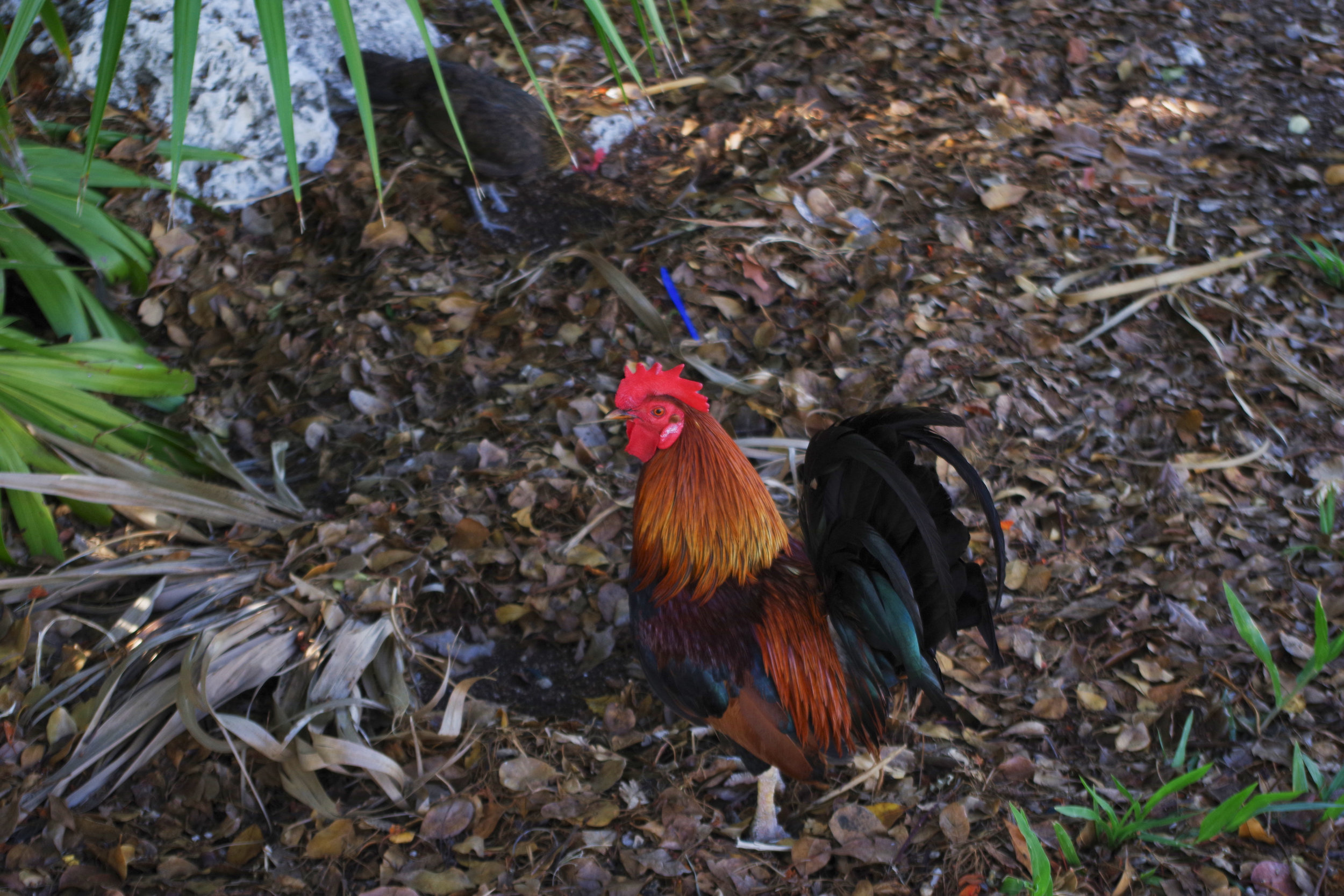
Steinhatchee (Pronounced Steen as I found out on Day 2) was supposedly the settlers way of saying the Native Americans name for the river -Esteenhatchee or Isteenhatchee. It is a small very rural fishing town, that is known for scalloping and also draws big crowds for the various other fishing seasons of the gulf. With everyone seemingly being from someplace else and just deciding at some point to stay, and to quote the movie “13th warrior” a village of barely a man (and woman) between 15 and 50. 2 gas stations with one also being the grocery store, the only chain anything being a Hungry Howies, Subway- in said grocery store, and a Dish network rep. The closest Wal-Mart? 18 miles away. Publix? 60.
The drive from Orlando was easy and uneventful, and finding the hotel, relatively painless even though we both lost cell service just as we entered town (take note fellow T-mobile/Metro users). The Steinhatchee River Inn had our suite ready and waiting for us, it was extremely clean, comfortable and well appointed, it is an older place but the family owners have done quite well keeping it up to date without losing its not a new building charm. After some unpacking and getting in touch with loved ones via wi-fi it was time to go learn the town, grab dinner, and decide what to do our first full day.


Day Two
Driving the coast and taking a trail drive.
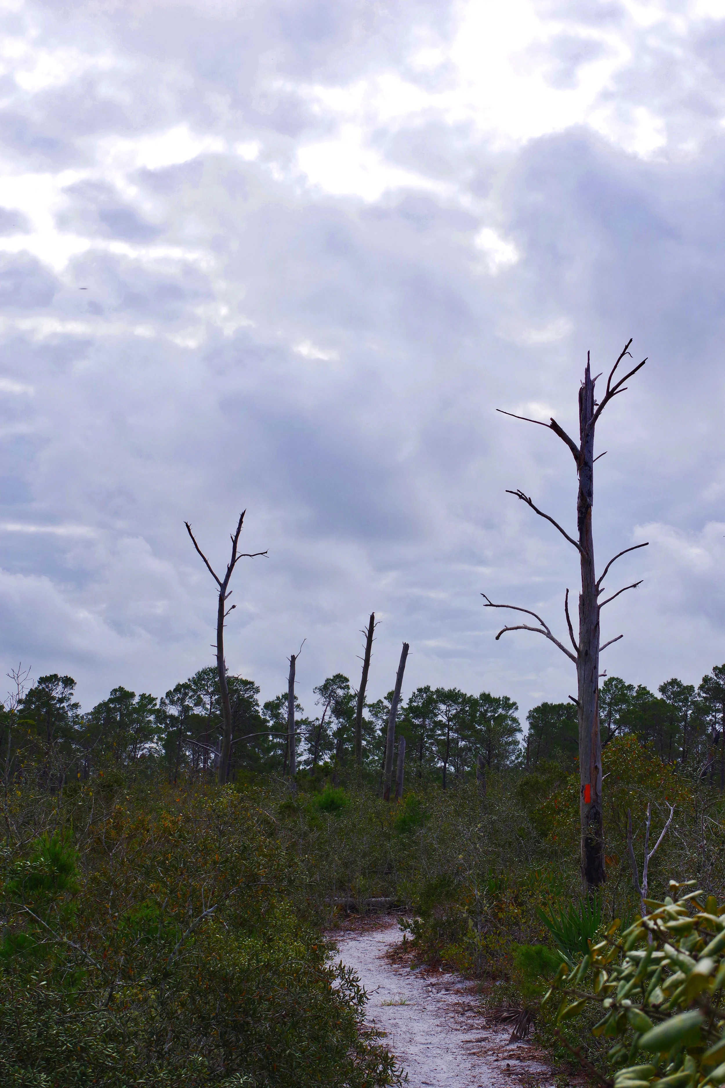
Plans for day two were simple. Explore. A stop here, and look there. The first major stop being about a 15 minute drive out of Steinhatchee at the North end of the Tide Swamp WMA. Hagen’s Cove, an interesting beach and trail area that showcases how insanely overcrowded and over built Florida’s east coast beaches have become.


Further driving-around 40 minutes worth, all of it down Beach Road/CR361/400. Was scenic and in some areas “spirited” driving friendly and all of it very well maintained. With small beach side communities popping up out of nowhere just to disappear again. The area as a whole could be described as coastal rural and sparse. After making it three quarters of the way to the city of Perry we decided to turn around and head back making a quick stop in the community (ok neighborhood) of Keaton Beach- no pictures unfortunately as the area was crowded with families.
Tidal Swamp WMA has a simply amazing nature drive road that winds through many of the landscapes the area has to offer. It seems well maintained although we did have to stop and muscle a fallen tree out of the road and even with the rain we were told the area had been getting had stayed high and dry. Multiple deer and turkey were spotted as well as a Coyote. Bring bug spray!
If a Miata on performance tires can do it anything can!
After making it back to town for showers and a quick lunch at the local bar then some TV/Internet time at the Inn. We got back in the Miata to check out the starting point of our biggest event of the trip. Steinhatchee falls….yes as in waterfalls.
Ok its not Victoria, or Niagra, but options in Florida are slim.
Steinhatchee falls is one of the few natural waterfalls in Florida, almost all being in the northern part of the state. The tallest being the 73 ft Falling waters, near the Florida-Alabama line. The near by hiking trails showcasing the lime stone “base” of this part of the state, with beautiful moss’s and ferns everywhere as well as unfortunately litter…at lot of it. Scattered throughout the park, especially near what looked like the popular fishing spots along the river. Such a horrible shame.


Day 3
Camera gear on an unscouted river
What could go wrong?
The next morning we woke up and walked across the street for our 9am appointment at the River Haven Marina & Motel. We signed some forms and had our ID’s copied, paid the extremely modest fee and walked to a truck that had our kayaks already loaded and a driver waiting. The drive was short and pleasant and the driver took us right to the drop off point a few yards downstream of the falls. After unloading and a friendly wave we were on our own. It was time to load up and head out. My brother and I both grew up canoeing and boating, I have kayaked before but it had been years. The kayaks are of the “all-around” type and had plenty of room for our gear. Which included- 2 gallons of water, a camelbak and bug spray in my brother’s kayak and a thermos and camera backpack with my Pentax, multiple lenses, action camera, and various goodies for both all various sized freezer bags for what turned out to luckily be untested added insurance, in mine.
After loading up, remembering how one safely gets a kayak in water and paddling around just below the falls to get the rust out we decided to set off on our 6 hour, 7 mile trip down the river.

Before long we were handing equipment and water between kayaks and even playing a bit of bumper boat from time to time.
Most of the journey down the river is heavily wooded and no more than 40 foot wide, with steep limestone banks on both sides. The water is tanic, clear and cool and judging by some of the fallen trees we saw hiding under the water very deep in spots. The river has a nice slow flow that make paddling unnecessary for more than steering. Due to the rain we did hit a few faster than we were prepared for spots, with my brother actually going backward at one point! The entirety of the first 2 hours of our journey we were totally alone and never heard or saw another person, slowly leading into more and more populated riverside living eventually climaxing into the Steinhatchee becoming a fully boatable river being 80 +/- yards wide with offshore fishing boats and full ocean capable 60 ft yachts moored to docks on either side belonging to large southern style houses or boating centric vacation condos.


Wildlife was not as abundant as I was hoping, however, it could be heard just out of eyesight whenever the cicadas would quiet down long enough this was probably due to the time of day (late morning to early afternoon) as well as the time of year. Setting off earlier in the morning or in the evening might result in more visible wildlife, something easily doable if using your own Kayaks and not having to worry about opening and closing deadlines of Kayak rental places. A heads up if setting off in for an end of day run or if the weather might be an issue: Once you are in the water you are committed to a realistic least of 3 1/2 to 4 hours of kayaking, as there are only a handful of beachable spots along the river and nothing but private docks along the entire trip until you return to your rental spot or one of the public ramps in Steinhatchee proper, although as friendly as all the locals were I am sure an emergency stop at one of the private docks would not be given problems.


Tired, hungry, and extremely sunburned from the journey my brother and I both agreed it was all more than worth it. We have caught the kayak bug and are both actively kayak and car rack shopping.
As mentioned before most of the run has a nice flow that keeps the paddling smooth (think any parks lazy river) as well as nice cover to keep things shaded. However this opens up for the last mile or so. The river widens, the flow slows, the shade goes away. Ahhh smell that bacon sizzle. We quickly regretted choosing bug spray over sunscreen (Why not both? We still aren’t sure.) With no current to help, a strong breeze, the sun baking us and water running low the last hour was an arduous one. By the time we reached the marinas kayak dock, it took all we had to roll ourselves onto the dock and lift the boats out of the water. A quick “Hey, we are back, Thanks!” Was all it took to drop the rentals off. Followed by crossing the street back to our room to clean up and plan our last night in Steinhatchee.
The idea to finish off this rare bro trip with closing down the local bar had been on the list since day 1. A see if we could walk the 1/4 mile back to the hotel and actually find our room kind of night. Spending the drive home in the morning regretting our decision and racing exhaust. Instead after cleaning up, having a celebratory beer a piece. It became clear all we wanted was dinner and “Oh look! NCIS marathon.” Yep the trip was over.
Steinhatchee is a great little town in one of the most beautiful parts of the state I’ve ever seen. Known for its scalloping and fishing, it and its surrounding areas are perfect for road trippers and daycationers alike. Friendly people, great food, affordable, and none of the catered to tourists feel most of Florida is known the world over for. Check it out!


Huge thanks to all the helpful locals!
Hotel: Steinhatchee River Inn
Kayak Rental & Drop-off: River Haven Marina & Motel
Food!: Roy’s Crabbie Dads Bar & Grill Kathi’s Krab Shack Hungry Howies Bar-B-Q Bills
Supplies & Gas: Maddie’s Market